
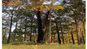
361 Blackhead Rd Hallidays Point is a 27 acre/10.63 h vital chunk of a designated koala habitat/corridor in Hallidays Point (1999 Council habitat study).
It is heavily forested and supports a range of wildlife on the threatened species list including brush-tailed phascogales, microbats as well as koalas. Hallidays Point is also a high bushfire risk zone that was heavily impacted in the Black Summer fires. (Google Holden Road fire truck ember storm).
361 Blackhead Road is a perfect example of the zombie DA phenomenon that is impacting all along the East Coast of NSW. In 2004 it was approved for an Aged Care facility including a nursing home despite it being in a high bush fire zone and vulnerable to local flooding.
At the time it was recognised that the development would also likely impact on threatened and vulnerable species with the result that the initial approval required the retention of “a significant tract of vegetation.” In October 2009 the DA was due to lapse but at the very last second a token gesture was made by removing some small saplings which saved the DA (although the receipt from the work done was dated a month later raising the question of whether the sapling removal actually occurred within the designated time period).
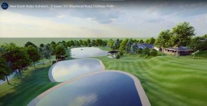
In May 2020 the DA again came up for approval, this time due to a modification from onsite building to essentially manufactured homes.
What was not made clear enough though is that it is now subject to upgraded Bushfire Risk Assessments and the upgraded BFRA which requires the whole block to be treated as an internal Asset Protection Zone with the destruction of almost all of the vegetation. This is to comply with less than 15% tree canopy and no vegetation near any of the intense building footprint. So this involves the removal of over two thousand trees and clearing, concreting and mowing of the bulk of the site.
The motion to accept the DA in the 2020 form was put forward by Councillor Len Roberts. It was narrowly passed by one vote.
Despite being a recognised koala corridor (with a koala sighted crossing the road nearby within the last month) and the site containing a number of koala food trees, this is not a consideration to prevent the clearing.
The presence of glossy black cockatoos and this small fringe of food trees is likely to be impacted by the road widening.
The displacement and probable loss of current wildlife is massive.
After the 2019-2020 fires this land has been an important part of the wildlife recovery. We also believe that the bushfire risk assessment is flawed in that it relied on an earlier assessment and did not include a current onsite visit. The plan also includes emergency exits onto private and E2 land that will not be permitted by current owners.
Placing an Aged Care facility in a high risk bushfire area is highly dubious given there is only one road out in case of another bushfire. The nearest hospital or ambulance service is at least 25 kilometres away.
The land sold last for 1.8 million dollars in 2019. With the modified DA approved in May 2020 it was rapidly put up for sale and was listed with Sotheby’s in Sydney for around the 20 million dollars mark.
The clearing of this land will effectively create a major gap in the corridor. It will add to the local extinction of a number of threatened species including koala, phascogales, microbats and spotted tail quolls. It will also put elderly and infirm residents at risk should there be another bushfire.
There is strong community opposition to the DA going ahead with most locals distressed by the loss of wildlife and also in disbelief that this is an appropriate place to site an elderly persons facility.
Kym Kilpatrick
(This is heartbreaking. Uncontrolled, inappropriate development has got to be monitored and accountable. As does our Council. Ed)